- Distance – 13.6 miles (22KM)
- Ascent – 4,000Ft
- Highest Point – Carnedd Llewelyn summit at 1,064 m (3,491 ft)
- Time Taken – Nine Hours
- Difficulty – Medium-to-Hard
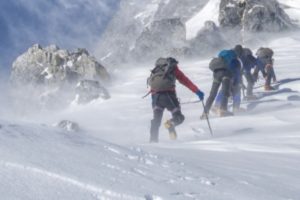
The northern side of Snowdonia is probably the best place in the UK for a challenging hike. When I say challenging, I mean challenging. They’re likely to no pathways, and the weather is more than likely to be terrible. To make matters worse, only really silly people want to go for a walk in this area. That said, if you’re up for a challenge, fantastic, rewarding place, that offers some of the best walking, climbing and hiking, the UK has to offer, then this area of Snowdonia is simply the in the UK.
For this challenge, we’re walking across the northern side of Snowdonia around the Carneddau Plateau. Generally, walks in this area are around 8-10 miles long, but due to the steep mountainous terrain, they can take anywhere from eight to ten hours to complete on a good day. Over the years, we’ve heard from many experienced hiking who’ve had problems and been forced to pull out the emergency gear.
Sadly, the weather and the steep mountainous terrain are not you’re only problems in Snowdonia. The other fundamental problem with walking in Snowdonia is that you often have to park the car in one area, walk and then either get the bus or use the two-car method to ensure that you see enough of Snowdonia to enjoy yourself.
The Route
Our route today is around 10 miles long and starts on the northern side of the Snowdonia. Effectively we’re going to walk from the middle of the A55 (starting from the hotel in Abergwyngregyn), to the middle of A5 (Anywhere around Gwern Gof Isaf campsite). For this walk, we’ve adopted the two-car method of leaving one car and the end and driving to the start meaning that we can quickly drive back to the beginning again to pick up the first car.
Our route takes us south to Aber Falls (about two miles and 600ft of climbing), on to the summits of Foel-Fras and Carnedd Llewelyn before finally considering the Pen yr Helgi Du Helgi summit. Our route finishes up on the A5 around Gwern Gof Isaf campsite where there is plenty of parking and a great place to leave the second car for the journey home.
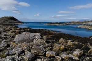
Aber Falls

From our hotel in Abergwyngregyn, the plan was to effectively walk due south firstly down the narrow lane from the A55 to Aber Fall Car park and then to join the pathway to Aber Falls. The path is clear and signposted, and while the weather was brilliant, there were a few boggy patches along the route.
We walked through the conifer plantation which made the trip shorter but did mean it’s steeper. If you just wanted a day hike, it’s possible to park in the carpark and walk down the Anafon River to the falls. This is a longer route but is much flatter. By the time I reached the waterfalls, my legs were burning, and the sweat was starting to develop. That said, Aber Falls is a fantastic place and well worth the views.
The waterfall is formed as the Afon Goch plunges about 120 feet (37 m) over a sill of igneous rock in the foothills of the Carneddau range. It is possible to swim in the plunge pool at the bottom of the falls, and I’ve heard great reports of the feeling you get when water falls on top of you from a hundred feet upwards, but its cold, even at the height of summer and care must be taken on the often slippery rocks.
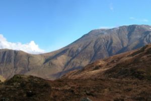
Foel-Fras
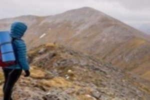
The next stop on our tour was Foel-Fras which is where this climb starts to get really difficult. From Aber Falls to Foel-Fras is about four-miles, however it four miles pretty or much up a hill and does take some time.
While it starts as a pathway, it quickly disappears, meaning that you’re walking on grass or mud for the majority of the climb. There are a few different paths to the summit, however, we found the easiest, and quickest way, was to follow the River Afon south until it starts to break away into different subsidiaries. By this point, on a clear day, you can see the summit on your left-hand-side. Again, there is a pathway to the summit, but we found it best to simply scramble our way up to the top.
One point, whether you’re on a pathway or not, the last five-hundred meters to the summits consists of rocks that you need to scramble over. We were lucky that it was dry, however, I can imagine in the wet, it can be tough to get over these slippery rocks. Make sure you’re wearing proper walking boots that support your ankles and are carrying walking-poles to support your knees and balance.
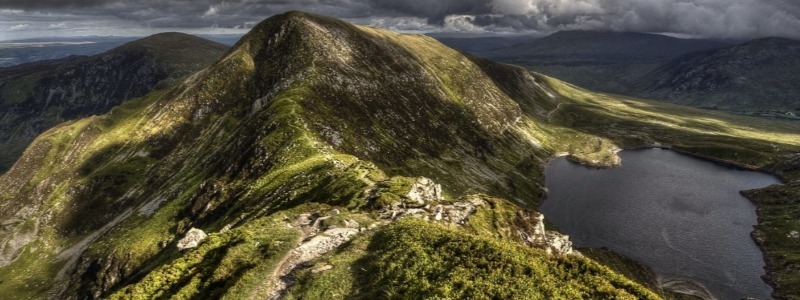
The summit of Foel Fras stands at 942 m (3,091 ft) making it one of the Welsh 3000s (mountains over 3000ft high). From the high point, there are beautiful views over Carneddau and the rest of Snowdonia.
To there North there are fantastic views of Foel Fras to Llyn Anafon and Ynys Seiriol, while to the south and west there are the slopes of Foel Fras, and to the eastern side of Foel-Fras, the Graveyard Slope (There were so many plane crashes between here and Foel Grach that the area was dubbed ‘The Graveyard’ by RAF Llandwrog’s MR team) of Foel Fras as this area is dotted with WWII air crash sites.
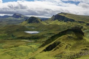
Carnedd Llewelyn
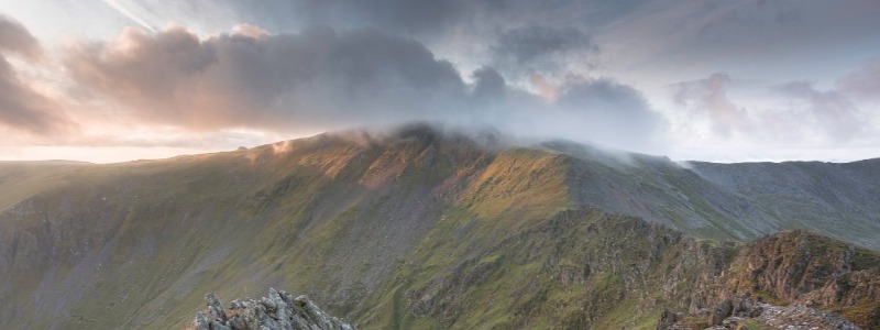
After a quick break for a spot of lunch as Foel-Fras, it was onwards to our next challenge and the Carnedd Llewelyn summit at 1,064 m (3,491 ft). This is the highest point of the Carneddau range and the second highest peak by relative height in Wales. In real terms, it only 21m lower than Snowdon at 1064m high and 1m lower than Carnedd Ugain.
The route from Foel-Fras to Carnedd Llewelyn is basically a four-mile hike, consisting of a mile of large rocks that you need to scramble over, taking care that you don’t damage your knees or ankles.
This is followed by two miles in the middle where firstly you decent into the hillside and in places it’s quite boggy, before starting your accent back upwards to Carnedd Llewelyn. Other than the last five-hundred meters, the walk is excellent, and there are some fantastic views of the surrounding countryside.
The five hundred meters to the summit of Carnedd Llewelyn is both steep and rocky and will take some time and attention to make sure you stay safe. The top can be identified by the cairn, and the views are some of the best you’ll find on a clear day.
Homewards
We had initially planned to walk home via the summit of Pen yr Helgi Du Helgi and given the most natural route home essential walks passed in any way, it wouldn’t have taken much time, however with us having walked eleven-miles over two 3,000 FT summits, the legs would not allow it.
As a result, we took the south-easterly path from the summit of Carnedd Llewelyn passed Pen yr Helgi Du Helgi to the left and the reservoir of Ffynnon Llugwy to the right and headed back to the second the car.
Finally
In total, we had walked 13.6 miles (22KM) with 4,000Ft of ascent and about 3,125Ft of decent in about nine hours. This is not a bad time, however, we did have great weather, and therefore there was minimal stopping or any compass work.
The routes are clear and with around eight miles being on marked walkways, and rest being clear routes. If the weather was terrible, possibly you’d need to bring your compass, but other than this, you’ll have no problems with basic navigation skills.
If you’re up the for challenge, this a great route to take home.