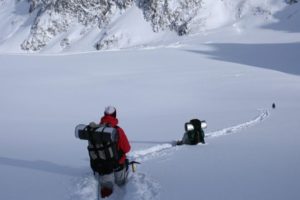
In the world we currently live in, navigation in the countryside is straightforward. That is, it’s straightforward until you run into problems. It’s very easy until you’re halfway up a mountain, and the fog comes in. You can no longer see where you’re going and worse still, the GPS that you’ve been relying on for directions, suddenly stops working because it can no longer find satellites.
In this situation you have two choices, pull out the emergency gear and sit it out for a few hours until you get a break in the weather, or pull out your map and compass, work out where you are, and in which direction you need to head to get to the next waypoint along your route, and keep moving.
Navigation Equipment
Whether I’m out for a day hike or a camping trip on a new route or a route than I know well, there are four bits of navigation equipment that I always take with me. I would recommend that you do the same;
- GPS – Two choices from Garmin which have the monopoly on the outdoor GPS units, depending on budget – The GPSMAP® 66i which has an internal, rechargeable lithium battery that provides up 200 hours in Expedition mode, however at over £400, it’s expensive or the much cheaper, Garmin etrex 32 which has a battery life up to 25 hours in GPS mode with 2 AA batteries
- GPS Watch – For on-route directions, I use a Garmin Fenix 6 watch. Typically, I pre-load the watch with my route. It’s rather basic, but reliable routing. Battery life is also very good. You should be able to get around 70 hours of GPS routing using the lowest setting, which is easily enough for four days use – just remember to switch the GPS off after use.
- Mobile Phone – As a backup, I carry my smartphone with a battery extender which provides as least three days of full GPS/Internet use, although I typically travel with it switched off in my backpack. On my smartphone, I typically have three different apps;
- Garmin Explore App
- Komoot – is free to download, but charges £29.99
- Viewranger – is free to download
- Map and Compass – For longer trips, I’ve been known to take solar panels with me to charge batteries as there is only so long a battery lasts, but if everything goes wrong, I also take a 1:2500 map of the area and compass and make a habit of drawing my route onto each map. This way, if everything went wrong, I would be able to have a basic understanding of where I am on the map and how to get home.
Pre-Plan your route
The first step to any expedition is to plan your route ahead of time. Once you’ve chosen your target area, the next job is to pin-point your starting location and carefully trace your planned route taking notice of any key features along your route. We discuss this further in our planning an expedition section, but its vital that you take this part of your walk seriously. Proper preparation will prevent problems later in the route.
While you’re planning your route, you need to think about how long the route will take. For preparation, I would use Naismith’s Rule, which suggests the average hiker walks 2.5 Miles in an hour in the open countryside and an additional 10 minutes for every 100 metres of ascent. Depending on your fitness levels and experience, walks much past 12 miles in the open countryside are best split up into two days and therefore require you to think about overnight accommodation.
Routing Software
When I first started walking in the countryside, you needed to pull out your ordinance survey map and draw your route onto your map. Next, you had to calculate your distance, ascent and descent values to make sure the distance was realistically possible.
Today this is all done using routing software. Personally, I think Komoot or Viewranger are your best options for the UK market. Both allow you to create a new route or choose from one of thousand of pre-planned routes across the UK.
Once you’ve planned your route, you need to download it as a GPX file and upload it through the Garmin Connect app on your computer to sync with both your GPS watch, your phone and your GPS Unit. (Obviously, this assumes you have a Garmin GPS)
GPS Waypoints
Before you start walking you need to make sure your route is working on your GPS Watch, your GPS handheld device, your smartphone and your physical maps are in your daypack or backpack. When I’m walking, I follow waypoints on my smartwatch that are located every few hundred meters along the route.
The handheld GPS is used when I run into problems or need to change a route due to a routing problem. At the same time, the smartphone applications and physical maps are all backups so that if my primary and secondary navigation aid fails, I can still get myself home.
Map and Compass
It’s very important to understand how to use a map and compass for those times when everything fails. There haven’t been many, but I have had the situation when the handheld GPS has run out of battery, and the smartphone could not find a signal leaving me walking blind. In this case, if it were not for the map and compass, we could have been in real trouble.
Reading a map and using a compass for directions is not difficult but is great to practice before you head to the countryside. Typically there are two parts to using a map and compass, working out where you are, and working out in which direction you need to go.
Where Am I?
In this situation where you’re trying to find your location, you have three methods – The Educated Guess, The Transit and The Triangulation. Before you start looking at maps and trying to work out where you are, you need to understand the scale of the map and what this means. Typically, I take maps with a scale of 1:25,000. This means that every 1cm on the map is equal to 250-meters in real life.
- The Educated Guess – If you planned out your route beforehand and have been following your route on a GPS, you should have a fair understanding of where you are along the route by merely looking at the map. If you look around you for any visible features or even gradient of the path you’re on, you can usually work out exactly where you located.
- The Transit – relies on you seeing two distinct features along your route. One needs to be something you’ve passed, the other in front of you. Effectively you line up the feature behind you, with the feature in front of you, with the same features on the map. Your location will be along that route.
- The Triangulation – uses the exact same plan as the Transit above with the only difference that you’re running multiple transits to pin-point your exact location. You need a minimum of three lines to pin-point your exact location, however, most people will use two, and guess the rest.
Where Do I Need to Go
Once you’ve worked out your location, next, you need to work out where you’re going, and the direction you should head. Before you start, you need to understand which way is North. North on a map is easy, it’s at the top of the map, but in real life, there is a difference between magnetic North (where your needle points) and true North.
When you’re following a compass, it’s important to understand these differences and how they will affect you. One degree out on your direction will send you off course by 35-Meters over the course of a mile.
Once you’ve set your compass to true North, place it on your map in the direction you want to go and read off the angle that you need to follow. As you follow the compass angle, make sure you’re heading the right direction every five minutes as it’s very easy to get off course. For a more in-depth video on how to use a compass, check out this video by REI below.
Final Thoughts
Navigation is not difficult these days, and there is no excuse for getting lost. Generally, when people get lost in the countryside, its because the weather has come in, the visibility has been reduced to zero, and they panick, rather than stop and think.
Remember, if you’ve got your emergency gear packed correctly, there is no reason not stop and wait out the bad weather until it clears. If all else fails, mountain rescue is there to help and will not mind coming to get you if you’re properly prepared.